I have been using Android based smart phone from 2+ years. I use it for different activities both on personal and professional levels. It has now become a part of my life and has made my life very easy and fast in one way or another. Yes. There are some negative points as well but I am fortunate to have more positives for having a smart phone.
Now I will cut this intro short and get to purpose of this entry. Recently I went to a service center of my telephony services provider as as I had some issues with internet from the day I had switched from post paid to pre-paid connection. While they fixed the internet issue on my phone, stupidly they applied a security pattern on my phone and unfortunately in the service center I didn’t check this. When I reached office and got a call on my phone I noticed this.
After noticing this, certainly I was very irritated and didn’t know what to do. I searched on internet and found quite a few solutions. Mostly they were trying to tell the users to reset their phone via resetting the phone to factory setting by going into boot menu of Android with some specific commands. I certainly didn’t like that idea and was looking forward for something more.
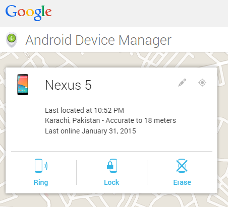
Then I realized that, I had added my phone to Google Device Manager (I would highly recommend that every Android device should be connected to this by their users) so I went there and saw this on my screen:
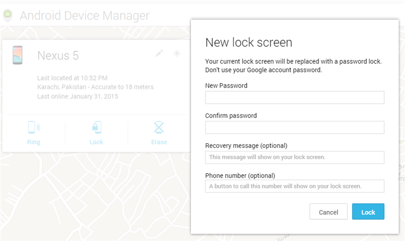
I realized this is something I was looking for. Clicking on the Lock screen, it showed me the below screen using which I set a temporary pass-code on my cell phone.
Doing this saved me from wasting time on resetting / cleaning all my data via Android special command or procedures. I know for geeks that would be worth trying but for someone who is only interested in restoring his phone, this will be the fastest way.
Also, using device manager if I ever want to reset my phone to Factory Settings I can do this via the Erase button on single click or by going to Settings -> Backup and reset -> Factory data reset. I don’t need to boot into Android boot menu via any special commands.
I have found this to very easy to follow and apply so I thought to share it on this blog to save time for others.
This is an entry I have been aiming to write from the day first when I started with my start up.
Why?
I had been working in a well reputed software firm in a very good position from 2005 without any major issues. Everything was cool and I enjoyed being there. I loved what I had been doing. However things started changing for me from 2011 end, when for the first time I felt I was not a good fit. I tried to switch my job responsibilities with in same organization but that didn’t help that much in the long run but still managed to spend some more time there. It was in April 2014 when this decision of parting ways after 8+ years was taken.
It was certainly not an easy one. Both on professional and personal level but sometime one has to step up and do something.
PivotalSigns is born!
After leaving, I had two options: Look for a job, which would offer job security, a continuous stream of income and such but I may face the same situation as I had in previous organization after sometime.
I discussed with my friends who are already doing their businesses (most of my friends are doing their own business :)). They encouraged me to try on my own before heading for job hunting. I will especially mention Aamir Ansari of Think Enabled, Fawad Moon of DevEnhanced, Khurram Zafar and Shah Khalid apart from many others who helped me in taking and finalizing this decision.
I acknowledge it was not an easy decision but it was something like now or never. So in May 2014 PivotalSigns was launched.
From the beginning when PivotalSigns was launched, we had decided that it will not be a merely outsourcing company, instead we will look forward for partnerships that last.
We are working on our own product ideas and working with clients to bring life to their ideas. Our core values are to provide quality services, work hard and remain honest with clients and customers throughout the project / product life style.
Going forward, I will try to share my experiences and learning on this journey.
When we first started our company, we slept in a garage, ate nothing but IKEA meatballs, and worked all of the time. Despite our effort, we did not manage our time very well and really had no idea what we were doing. Read More
I have got my Kindle Touch a few weeks ago and I have been using it very regularly.
Reading Experience: When I bought it my main question was will I be able to read the PDF books? I knew it is one of the best device for English books reading but I was going to use it both for English and Urdu PDFs. So even before ordering, I was a bit nervous if it would handle it or not. But it is opening and rendering the PDF documents I have in both languages smoothly and the touch system is also a blessing as I have to do a lot of zoom in/out. So I would give 9/10 for this PDF support.
Also, I have used it both in sunlight and power lights at night / room and it is easy on eye and gives a good feeling.
Touch System: This is Amazon’s first touch Kindle device and I would say it is not bad. I agree it doesn’t match the quality of touch from Apple but at this price and the purpose for which this device is used, I am pretty satisfied with it.
Size and Weight: I really liked this device’s size. One could hold it in one hand and read for hours without any difficulties as this is very light weight.
Battery Life: This was one of the high point for me to buy this. Daily I read for about 1-1.5hrs on average and while reading due to the PDF documents, I have been zooming in / out and the battery it consumes is very less.
Experimental: There are some experimental features in this like web browser and mp3 player. Although I am not using them regularly but they worked pretty fine.
Connectivity: Being registering this device in Pakistan and using it from here, I don’t have access to the amazon services directly but via WiFi, I am able to browse Amazon Kindle Store and other websites via its experimental web browser. It was pretty easy to setup my WiFi in Kindle.
Overall I am very satisfied with this and I would recommend this for any one who likes to read. There was only one negative point which I didn’t like was to not have the power adapter included in normal purchase. It is sold separately. I didn’t know this when I ordered it and it was not easy for me to order a separate item again as my friend was bringing this for me from US.
Duration: 6 Days
Distance: 37 Km
Standard: Easy
Season: June ~ October
Start / Finish: TARASHING
Zone & permit: Open
Public Transport: Yes
Summary: A Quick approach through lovely meadows leads to the base camp of NANGA PARBAT’s enormous RUPAL face.
NANGA PARBAT’s awesome south or RUPAL face rises 4572m from the floor of the RUPAL GAH, creating the greatest vertical rise from base camp to summit of any peak. The easy trails and two short no technical glacier crossings bring you directly beneath it for breathtaking close-up views, is less frequently visited than fairy meadows.
Guide & Porters
It’s prudent to hire a reputable, licensed guide who is accustomed to dealing with RUPAL porters and villagers. Porters come from TARASHING and CHORIT, which have decided that an equal number of porters for any party are to be from each village. This holds true even if you have just two porters. Porters, who transport loads on donkeys, ask for a flat rate of Rs.300 per stage, including payment for food rations and expect large parties to buy a goat at SHAIGIRI.
Stages
It’s a six stages total round trip from TARASHING:
1. HERRLIGKOFFER Base Camp
2. LATBOH
3. SHAIGIRI & (4-6) there stages to return via the same route.
Nearest Village:
TARASHING
Hotels / Rest Houses: NANGA PARBAT TOURIST COTTAGE: owned by Mohammed Ashraf, has a large garden. The Camping fee is Rs.100 and rooms cost Rs.250 ~ 400.
HOTEL NANGA PARBAT: has a Rs.100 camping fee and rooms cost Rs.200 ~ 300.
Unless you organize a Gilgit ~ TARASHING special hire (Rs 2500/4000 one way / return), it’s necessary to change transport in Astor. The narrow jeep road to Astor leaves the KKH at Jaglot, 60Km south of Gilgit and 30Km north of Raikot Bridge, crossing a bridge over the Indus river and heading 40Km south – east up the Astor Valley skirting NANGA Parbat’s north east flank. Gilgit ~ Astor jeeps (Rs 100, three to four hours) go all day from Gilgit’s Jaglot bus stand on Domyal Link Road. Gilgit ~ Ator special hires cost Rs 1200 ~ 1500 one way. Astor ~ TARASHING Jeeps cost Rs. 50 (two hours) and special hires cost Rs 1000.
THE TREK:
Day 1: TARASHING to HERRLIGKOFFER Base Camp
5 Hours, 10 Km, 639m Ascent
From TARASHING (2911m) climbs the TARASHING Glacier’s lateral moraine, near the village’s north edge, and crosses the glacier on a trail, continues up to the gentle valley through RUPAL village.
Rising gradually through RUPAL’s lush fields, the trail follows the valley’s north side up a narrow green valley, through groves of willow, poplar and juniper then you pass a small lake and round a corner of the BAZHIN camp, a flat, green meadows between the lateral moraine of the BAZHIN Glacier and the mountain. Ahead towers the solid ice wall of the east face of NANGA PARBAT. This is a perfect campsite with clear spring water, a wood full of birds this spot is called HERRLIGKOFFER Base Camp (3550m), a beautiful, although much used meadows along the BAZHIN Glacier’s east margin. The camp site is named after Dr. Karl M HERRLIGKOFFER the leader of eight German expeditions to NANGA PARBAT, including the first successful expedition in 1953.
A side trip of several hours up this ablation valley leads to a point on the moraine directly above the BAZHIN Glacier and across from icefall coming from the summit.
Day 2: HERRLIGKOFFER Base Camp to LATBOH
4 Hours, 3 Km, 20m descent
Crosses the BAZHIN Glacier over a trail in 1½ hours along a donkey path, the local shepherds come and go frequently, so you can follow their path or them but be careful there will be a lot of hidden crevasses and you can listen to the voice of flowing of under ground water so you must walk slowly and don’t stop at the BAZHIN Glacier. From the top of the lateral moraine on the western side you look down on a huge grassy field known as LATBOH (3530m), the broad level meadows frequently by RUPAL herders. LATBOH is also known as TUPP Meadows because it’s like a TUPP which must once have been the bed of a lake. Herds of horses, sheep and goats graze in the centre. The summer villagers churn butter in goatskins and spin sheep wool while they sit and chat, offering bread and buttermilk (LASSI) to visitors.
Day 3: LATBOH to SHAIGIRI
4 Hours, 5.5Km, 125m ascent
A further two hour takes you around the end of a second moraine, with a lake on the top (Basically this Lake is less frequently visited & has no name and it exists at the foot of NANGA PARBAT so that is why I gave it a name “NANGA PARBAT Lakeâ€) to another broad field, LATBOI (meaning stony place) also called second Base Camp, with a summer settlement on one side, from here the path climbs gently over some moraine then follows the north bank of the river through the woods to SHAIGIRI (meaning “white stone†in Shina) 30 minutes away. This is a good campsite at about 3660 meters, with fresh water, firewood and superb views of the south face of NANGA PARBAT.
Day 4 ~ 5: SHAIGIRI to TARASHING
2 days, 18.5Km, 744m descent
Retrace steps to TARASHING, Camping at base camp on day 4.
So what do you people say, any expectation or idea to go for Traveling, Tracking etc in June or July 2010 to Northeren Areas?
I need your recommendations and who is going?
I am quite amazed to see you you get tired from work only in a few days? You have been going to some day trips from the last few months (In Dec to Hub and in Jan to Haleji Lake). You still feeling tried?
Prepare a plan for Kaghan and surrounding area treks this year.
Wsalam
-Meraj
=========================Sheraz Sohail Awan said====================== AOA,
Dear All,
yes i think June or July will be fine with me. infact i will also visit Kaghan and Naran valley this year with my friends and our families.
we have a program set for May or June and for three days on our own transport.
so you now better decide which way to go. we also discussed about Naltar Pakora Trek once. or it could be some where else.
Shujaat you plz give us two or three options, then we will see which one is better for this year.
I have done the following trek last year so if any one needs more information, then please comment below. PROPOSED PLAN : Rakaposhi Peak
Day 1 – Saturday 21st June 08: Start from Lahore at early in the morning from Daewoo Bus and reach at Pindi at 1:00 PM and go to Peer Vedai Bus Stand and get the seats of NATCO Ac and at 4:00 Pm bus will start for Gilgit
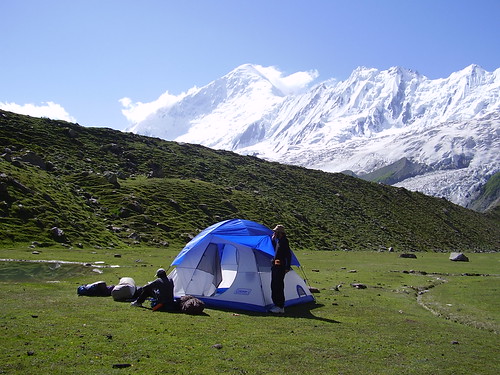
Day 2 – Sunday 22nd June 08: Reach Gilgit in the morning and immediately get seated for MINAPIN so that we will reach MINAPIN. It takes almost 3 to 4 hrs from Gilgit to MINAPIN. At MINAPIN we will try to stay at DIRAN Guest House or we will camp at the campsite of DIRAN Guest House. So that is the day we will have to search for a Guide, Porters + Donckey & a Cooker.
Day 3 – Monday 23rd June 08: Today is our 1st day to Trek by foot from MINAPIN to HAPAKUN 3 ~ 4 Hours, 5.8km, 792m ascent (See Detail + Map & camp at night at HAPAKUN
Day 4 – Tuesday 24th June 08: Today our destination is HAPAKUN to TAGAPHARI 2 ~ 3 Hours, 3km, 457m ascent
View of Rakaposhi from Tagaphari
(See Detail + Map) & Camp at TAGAPHARI.
Day 5 – Wednesday 25th June 08: At TAGAPHARI we will see our health + body condition & decide that will we go to KACHELI LAKE (See Detail + Map) OR Way back to MIAPIN via GUTUMERUNG & ASKORESHUNG (See Detail + Map).
If KACHELI LAKE :
If we decided to go to KACHELI LAKE then we will Trek on 5th Day to KACHELI LAKE via DIRAN BASE CAMP and stay night at KACHELI LAKE.
Day 6 – Thursday 26th June 08: Today we will try to come back to HAPAKUN via TAGAPHARI.
Day 7 – Friday 27th June 08: Today we will try to reach GILGIT via MINAPIN.
If way back to MIAPIN via GUTUMERUNG & ASKORESHUNG:
If we decided to go to GUTUMERUNG & ASKORESHUNG then on 5th day we can see both places in a day and at night camp atHAPAKUN.
Deran Peak with Rakaposhi massif
Day 6 – Thursday 26th June 08: Today we will try to come back to MINAPIN & do rest a night at Diran Guest House.
Day 7 – Friday 27th June 08: Get a van early in the morning for GILGIT & do shopping at Gilgit whatever you like and try to get the seats for Pindi at NATCO.
Day 8 – Saturday 28th June 08: Reach INSHA ALLAH at Pindi and get the seats for Lahore and at night we will be at Lahore & Sunday will be for a rest day for you to start to go to office on Monday and live in the memories + dreams of this Trek for a year and next year INSHA ALLA for our program will be of K – 2 Base Camp.
IMPORTANT NOTE : Camping at Rakaposhi base camp
So brother this is the plan, but it is an ideal plan. I haven’t counted for certain uncertainties like
Weather factor, landslide
Health problem
May be Trek is more tough than we think so then we shall have to add at least a day for trekking.
THINGS TO TAKE :
Following is the list of things that each person has to bring along:
View of Rakaposhi from Tagaphari
Hiking bag (must be reliable and shoulder strips must be strong enough)
Sleeping bag (preferably light weight but more warm)
Shoes preferably like army shoes or something that have designed pattern in its sole so to facilitate walking on slopes and snow. Slipper must also be taken along because after a tough trekking in the day, u needs to relax your feet after reaching the camping place. You cannot wear long shoes all the time.
Sunglasses are also very necessary item. because there is immense sunshine around glaciers that can have adverse effect on eyes.
Personal things like shaving kit, towel, spare under garments, spare socks etc
Other optional things may include camera, Walkman, note book (for taking some notes), torch etc.
Now I am noting down the things which we need to take as a group (you don’t have to worry about these as we will share them)
Tent: I have a tent for 6 persons.
Eatable items; Although I hope that in that season we can have some help from summer settlements all along the trek, but we shall keep our ration in any case). I shall buy tinned food and some dry ration like biscuits etc from Karachi / Lahore so please tell me that what will you like to eat & can I buy all from Karachi or at Lahore with you people.
Certain other instantly cooks able things like Haleem in Tin, Fish in Tin, Beans in Tin, Biryani in Tin.
Packets of something like TANGS, Toffees, Pineapples Tins.
Utensils: we shall buy some (2 or 3) aluminum bowls for heating water which shall be used for tea, noodles as well as for warming tinned food. Anther things include plates, spoons, disposable or plastic cups etc.
Medicines, mosquito repellent, desprine, panadol.
EXPENDITURE : Clear View of Diran Peak in the morning
The estimated cost of our trip is about rs.10000/head. It is from Lahore to Lahore and include:
Bus fare from Lahore to Pindi & Pindi to Gilgit and back.
All meals plus food items purchasing
Charges of guide and porters.
Expenditure of hotel (if any night spent)
I must mention that these are not the charges like travel agencies that you have to pay. You will see we shall have a transparent accounting of all the expenditure daily. Whatever will be the expenses shall be equally shared by all of us. Rs.10000/head are the roughly estimated charges, as we don’t know rates of many things. So safely we must carry some extra money with us. There may be chance that if we get porters / guide at lesser rates, the overall charges drop to 8000/- but nothing can be said at this stage.
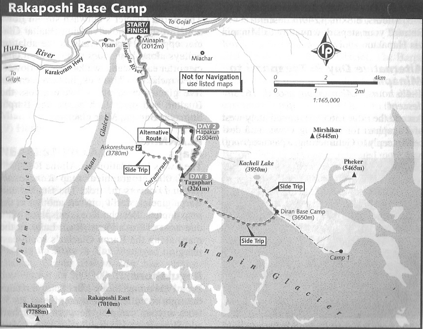
INFORMATION ABOUT THE RAKAPOSHI BASE CAMP :
Duration 3 ~ 4 Days
Distance 17.6 km
Standard Easy
STAGES :
It’s four stages total round trip from
HAPAKUN
TAGAPHARI
tow stages to return via the same route.
PLACES TO STAY & EAT : MINAPIN’s ground zero is DIRAN Guest House. The gracious hosts, well prepared food and peaceful grassy compound with orchard – shaded gardens distinguish this as one of the Northern Area’s most tranquil places to stay. The dorm cost Rs. 70, and single/doubles cost Rs.400/600, all with hot running water. The camping fee is Rs. 100. If you need a place to really rest and hang out for a few days between treks, this is it. It also rent tents, sleeping bags and kitchen equipment and sell limited food but it’s advisable to bring all trek food and supplies from GILGIT or KARIMABAD. GETTING THERE AND AWAY :
Public vans to PISAN and MINAPIN depart GILGIT’s Khazana (Bank) Rd new Golden Peak Inn, usually between 1and 2pm. they’re unmarked and can be hard to find. The three-hour ride cost Rs.50, plus Rs 10 per backpack or duffel bag. The 4km long road to MINAPIN leaves the KKH at PISAN, just east of GHULMET. From PISAN, it takes 45 minutes to walk to MINAPIN. The same public vans depart PISAN and MINAPIN daily for GILGIT at 6.15am.
When the MINAPIN vans are full, try PISAN and MIACHAR vans. The PISAN vans depart GILGIT before the MINAPIN vans, usually between noon and 1pm. The MIACHAR vans depart GILGIT about an hour after the MINAPIN vans. GILGIT – bound MIACHAR vans pass the DIRAN Guest House about 7am, but are usually already full.
No direct transport links MINAPIN with KARIMABAD, so just get to the KKH and jump on any passing vehicle. KARIMABAD – MINAPIN special hires cost Rs.1000.
THE TREK :
Day 1: MINAPIN to HAPAKUN
3 ~ 4 Hours, 5.8km, 792m ascent
From DIRAN Guest House (2012m), follow the road two minutes east. Then turn south (right) onto a dirt lane and follow it five minutes to the canal along the village’s south end. Turn west (right) and follow the path along the canal 15 minutes towards the MINAPIN River. Walnut trees shade the path and provide a home for nesting orioles (MAIUN). The trail turns south into the canyon and crosses a footbridge (2103m) over the rushing to the river’s true left bank after 10 minutes.
The trail rises 183m on switchbacks for 30 minutes then eases of and enters an open, aromatic juniper forest. Continues along the broad, shaded trail, rising gradually in one to 1 ½ hours to the huts at Bang – i – das, long a clear stream that tumble over a cascade at the head of this pleasant side valley. The trail follows the stream 30 minutes to the base of waterfall, where it forks. The right fork, which crosses the stream over a footbridge, leads to GUTUMERUNG (alternate route). Follow the smaller left fork and climb 90m in 15 minutes to the grassy, tiered meadows of HAPAKUN (2804m) bordered by stands of mature fir trees. The BURUSHASKI name HAPAKUN is given to a place (kun) within a day walk of a main village, which is defined as ‘close enough to carry child’ (HAPA).
Camping is free in the open meadows, with northern views of HACHINDAR and MAIUN Peaks above the HUNZA River. DIRAN and RAKAPOSHI remain hidden from view. Ibex inhabit the steep cliffs to the east high above MINAPIN Glacier. A small, sometimes silty stream flows near the herder’s huts HAPAKUN, but a clear spring lies behind and five minutes below the huts. It cost Rs.40 – 50 to camp on private land near the spring.
Day 2: HAPAKUN to TAGAPHARI
2 ~ 3 Hours, 3km, 457m ascent
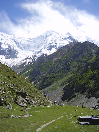
Crossing the canal between the two huts, the trail (the one perpendicular to the canal, not parallel to it) heads south, rising across rock-strewn open ground beyond HAPAKUN’s largest hut – for a minute or two – and then climbs immediately west up dusty switchbacks through fir forest for 14 minutes. The trail eases off and contours the rocky slopes foe 30 minutes to a verdant bowl where wildflowers and colorful songbirds thrive. Sweeping gently through the meadows, the trail enters scattered juniper stands and climb switchbacks to the windy ridge top, where DIRAN, RAKAPOSHI and their interconnecting ice wall finally come into full view.
The trail thins and traverses a rocky cliff above the spectacularly broken MINAPIN Glacier 15 minutes to TAGAPHARI (3261m). Once a muddy (TAGA) lake (PHARI), as its BURUSHASKI name indicates, it’s now a level pastures where cows and oxen graze. A herder’s hut is next to the rocky hillside, with plenty of good grassy campsites along the meandering stream. A small seasonal spring lies at the base of rocky slope towards the head of this small valley. The lateral moraine above the valley is a fun place to watch avalanches crashing down from the ridge between RAKAPOSHI and DIRAN, and to catch the sunset on DIRAN. RAKAPOSHI itself is mostly hidden from view behind the obvious snow down of RAKAPOSHI Eat (7010m).
Side Trip: ASKORESHUNG
3 Hour, 5.8km, 1319m ascents, 1319m descents
ASKORESHUNG (ASKOR means a ‘flower’; SHUNG, a ‘narrow path’) is a view point (3780m) atop the second ridge west of TAGAPHARI from where the BATURA, SHISHPER and ULTER peaks above HUNZA are visible. From TAGAPHARI, ascend steeply west to the first ridge (3650m), descend and cross the intervening GUTUMERUNG stream, reaching the second ridge on two hours. Return to TAGAPHARI in one hour.
Side Trip: DIRAN Base Camp
7~8 hours, 12km, 389m ascent, descent
DIRAN base camp is locally known as KACHELI, a BURUSHASKI word meaning ‘the best grazing grass”. MINAPIN and MIACHAR villagers share these birches – dotted pastures. The area, along the MINAPIN Glacier’s north – east margin, is similar to TAGAPHARI with good campsite and a small spring nearby. Visiting KACHELI Lake as a day hike from TAGAPHARI is a more strenuous, but less expansive option than camping at KACHELI and paying porters for two additional stages (one there, one back).
From TAGAPHARI, follow the crest of the lateral moraine south 20 to 30 minutes to the small cairn (3510m) marking the route onto the glacier. It takes three hours to cross the broad MINAPIN Glacier and reach DIRAN Base Camp (3650m). The unmarked route north – east across the glacier’s alternating bands of rock and ice near many Seracs is difficult to follow and changeable, so take a local guide or porter who knows the way. Carry a rope for safety. Watch marginal crevasses when existing the glacier.
From DIRAN Base Camp, trekking south – east up the ablation valley towards the rocky bend (4040m) in the glacier brings you to the point where the route to camp 1 moves onto the glacier, close beneath DIRAN. Enjoy the view, but don’t continue onto the heavily crevassed glacier. Experienced climbers can attempt PHEKER (5465m) from base camp.
Side Trip: KACHELI Lake
3 hours, 8km, 300m ascents, 300m descents
It takes two hour to climb steeply to the small KACHELI Lake above DIRAN Base Camp, and half that to return.
Day 3: TAGAPHARI to MINAPIN
3 ~ 3 ½ hours, 8.8km, 1249m descent
Retrace your steps down valley to MINAPIN via HAPAKUN.
Alternative Day 3: TAGAPHARI to MINAPIN
4 ~ 4 ½ hours, 8.4 km, 389 ascent, 1639m descent
Ascend the ridge (3650m) immediately west of TAGAPHARI for sweeping views and descend steeply to GUTUMERUNG, a pasture (rung) in this deep (GUTUM) valley where sheep and goats graze. Follow the trail steeply downstream (north) until it passes the waterfall at the head of the Bang – i – Das Valley and joins the rail between HAPAKUN and MINAPIN.
I am sending you the Rakaposhi_Base_Camp_Map so 1st read the Maps at Attachment then 2nd read Plan & then read the above detail information.
PROBLEMS IN ACCOMPLISHMENT OF TRIP
June is rainy season, so if we come to know about closing of KKH before starting the trip we may have to re-think of our trip.